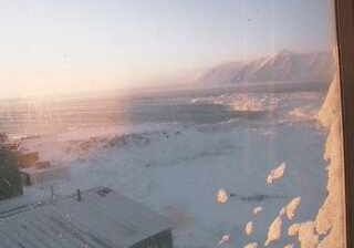
Rancho Cucamonga: Cucamonga Peak
![]() Rancho Cucamonga, Bandaríki Norður-Ameríku
Rancho Cucamonga, Bandaríki Norður-Ameríku
Real-Time Environment
Welcome to the live streaming webcam for Rancho Cucamonga: Cucamonga Peak, perfectly situated in the vibrant region of Rancho Cucamonga, Bandaríki Norður-Ameríku. Watching this live camera allows you to instantly experience the local atmosphere and monitor current climate conditions.

About Rancho Cucamonga
Rancho Cucamonga was a 13,045-acre Mexican land grant in present-day San Bernardino County, California, given in 1839 to the dedicated soldier, smuggler and politician Tiburcio Tapia by Mexican governor Juan Bautista Alvarado. The grant formed parts of present-day California cities Rancho Cucamonga and Upland. It extended easterly from San Antonio Creek to what is now Hermosa Avenue, and from today's Eighth Street to the mountains.
📖 Read more on Wikipedia📍 Location Facts
-
Country
 Bandaríki Norður-Ameríku
- Region Kalifornía
- City Rancho Cucamonga
- Coordinates 34.2333°N, -117.5967°E
Have you been to Rancho Cucamonga?
Help the community! Share your experience, tell us about the weather, or upload your own photos from this exact location.